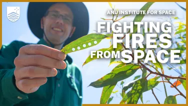
Developing fuel moisture sensing satellites for fire management with Indigenous knowledge

This pilot project set out to cross-calibrate advanced satellite remote sensing technologies and Aboriginal and Māori knowledge systems for fire management. By combining Earth Observation tools with place-based cultural assessments, the project aims to develop more effective and ethical fire preparedness strategies.
The Indigenous Pathways to Advance Fuel Moisture Earth Observation Technologies for Improved Fire Planning Management Strategies project is a first of its kind. With the goal to co-create two-way learning pathways between Indigenous communities and researchers, strengthening cultural leadership in science and land management while building Indigenous capability in geospatial tools.
Scientists from the ANU Fenner School of Environment and Society and the Bushfire Research Centre of Excellence have partnered with Indigenous fire practitioners from Gadungaal Yuin Country, while also collaborating and learning from visiting Māori researchers from Scion Group, New Zealand, for this project. The team is using technology developed by researchers at the ANU Advanced Instrumentation and Technology Centre (AITC).
This video includes footage from Gadungaal Yuin, Ngunnawal & Ngambri Country. We acknowledge the Gadungaal Yuin, Ngunnawal & Ngambri Country communities as the Traditional Custodians of these lands, and pay our respects to their Elders past and present.
This work has been supported by the SmartSat CRC, whose activities are funded by the Australian Government’s CRC Program, and the New Zealand Ministry of Business Innovation & Employment.
Read more

Since colonisation cultural burning in the Great Sandy Desert ended. Now the work of caring for desert country (pirra) with fire (jungku, or warlu) has begun again.

ANU ecologists and a cohort of New South Wales Local Aboriginal Land Councils are joining together on a project to re-introduce cultural burning in box-gum grassy woodlands and to monitor the environmental outcomes of the burns.