Unprecedented heat in the North Atlantic Ocean kickstarted Europe’s hellish 2023 summer. Now we know what caused it
By Matthew England, UNSW Sydney; Alex Sen Gupta, UNSW Sydney; Andrew Kiss, Australian National University, and Zhi Li, UNSW Sydney
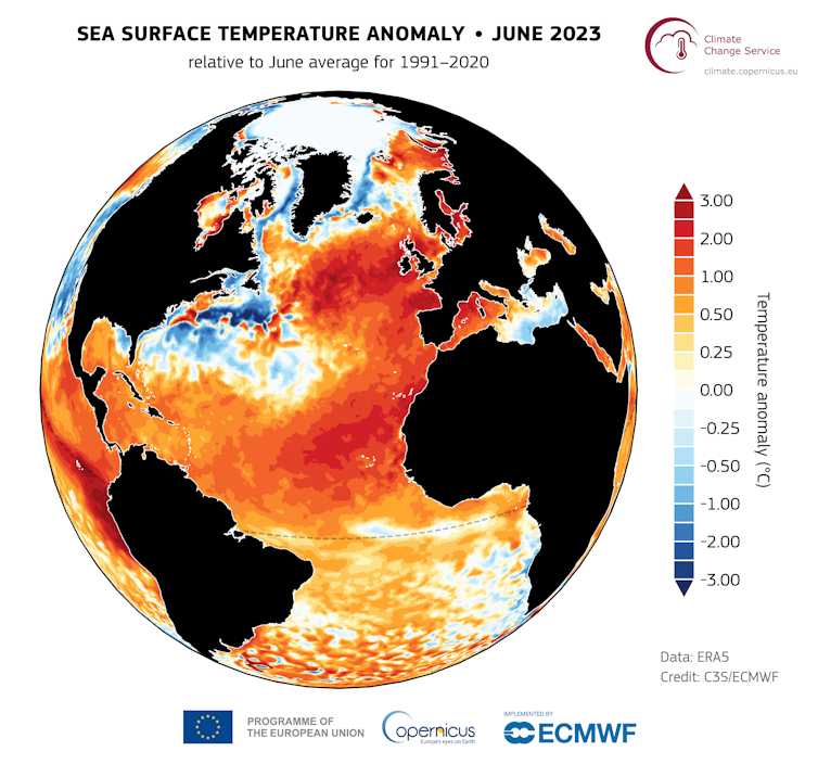
In June 2023, a record-breaking marine heatwave swept across the North Atlantic Ocean, smashing previous temperature records.
Soon after, deadly heatwaves broke out across large areas of Europe, and torrential rains and flash flooding devastated parts of Spain and Eastern Europe. That year Switzerland lost more than 4% of its total glacier volume, and severe bushfires broke out around the Mediterranean.
It wasn’t just Europe that was impacted. The coral reefs of the Caribbean were bleaching under severe heat stress. And hurricanes, fuelled by ocean heat, intensified into disasters. For example, Hurricane Idalia hit Florida in August 2023 – causing 12 deaths and an estimated US$3.6 billion in damages.
Today, in a paper published in Nature, we uncover what drove this unprecedented marine heatwave.
A strange discovery
In a strange twist to the global warming story, there is a region of the North Atlantic Ocean to the southeast of Greenland that has been cooling over the last 50 to 100 years.
This so-called “cold blob” or “warming hole” has been linked to the weakening of what’s known as the Atlantic Meridional Overturning Circulation – a system of ocean currents that conveys warm water from the equator towards the poles.
During July 2023 we met as a team to analyse this cold blob – how deep it reaches and how robust it is as a measure of the strength of the Atlantic overturning circulation – when it became clear there was a strong reversal of the historical cooling trend. The cold blob had warmed to 2°C above average.
But was that a sign the overturning circulation had been reinvigorated? Or was something else going on?
A layered story
It soon became clear the anomalous warm temperatures southeast of Greenland were part of an unprecedented marine heatwave that had developed across much of the North Atlantic Ocean. By July, basin-averaged warming in the North Atlantic reached 1.4°C above normal, almost double the previous record set in 2010.
To uncover what was behind these record breaking temperatures, we combined estimates of the atmospheric conditions that prevailed during the heatwave, such as winds and cloud cover, with ocean observations and model simulations.
We were especially interested in understanding what was happening in the mixed upper layer of water of the ocean, which is strongly affected by the atmosphere.
Distinct from the deeper layer of cold water, the ocean’s surface mixed layer warms as it’s exposed to more sunlight during spring and summer. But the rate at which this warming happens depends on its thickness. If it’s thick, it will warm more gradually; if it’s thin, rapid warming can ensue.
During summer the thickness of this surface mixed layer is largely set by winds. Winds churn up the surface ocean and the stronger they are the deeper the mixing penetrates, so strong winds create a think upper layer and weak winds generate a shallower layer.
 Sea surface temperature anomaly (°C) for the month of June 2023, relative to the 1991–2020 reference period. Copernicus Climate Change Service/ECMWF
Thinning at the surface
Our new research indicates that the primary driver of the marine heatwave was record-breaking weak winds across much of the basin. The winds were at their weakest measured levels during June and July, possibly linked to a developing El Niño in the east Pacific Ocean.
This led to by far the shallowest upper layer on record. Data from the Argo Program – a global array of nearly 4,000 robotic floats that measure the temperature and salinity in the upper 2,000 metres of the ocean – showed in some areas this layer was only ten metres deep, compared to the usual 20 to 40 metres deep.
This caused the sun to heat the thin surface layer far more rapidly than usual.
In addition to these short term changes in 2023, previous research has shown long-term warming associated with anthropogenic climate change is reducing the ability of winds to mix the upper ocean, causing it to gradually thin.
We also identified a possible secondary driver of more localised warming during the 2023 marine heatwave: above-average solar radiation hitting the ocean. This could be linked in part with the introduction of new international rules in 2020 to reduce sulfate emissions from ships.
The aim of these rules was to reduce air pollution from ship’s exhaust systems. But sulfate aerosols also reflect solar radiation and can lead to cloud formation. The resultant clearer skies can then lead to more ocean warming.
Early warning signs
The extreme 2023 heatwave provides a preview of the future. Marine heatwaves are expected to worsen as Earth continues to warm due to greenhouse gas emissions, with devastating impacts on marine ecosystems such as coral reefs and fisheries. This also means more intense hurricanes – and more intense land-based heatwaves.
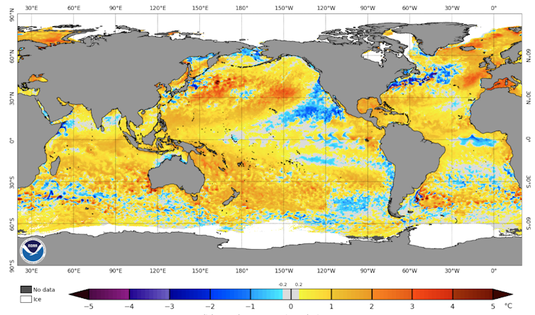
Right now, although the “cold blob” to the southeast of Greenland has returned, parts of the North Atlantic remain significantly warmer than the average. There is a particularly warm patch of water off the coast of the United Kingdom, with temperatures up to 4°C above normal. And this is likely priming Europe for extreme land-based heatwaves this summer.
 Global ocean temperatures on June 2 2025. A patch of abnormally warm water is visible off the southern coast of the United Kingdom. National Oceanic and Atmospheric Administration
To better understand, forecast and plan for the impacts of marine heatwaves, long-term ocean and atmospheric data and models, including those provided by the National Oceanic and Atmospheric Administration (NOAA) in the United States, are crucial. In fact, without these data and models, our new study would not have been possible.
Despite this, NOAA faces an uncertain future. A proposed budget for the 2026 fiscal year released by the White House last month could mean devastating funding cuts of more than US$1.5 billion – mostly targeting climate-based research and data collection.
This would be a disaster for monitoring our oceans and climate system, right at a time when change is severe, unprecedented, and proving very costly.
This article is republished from The Conversation under a Creative Commons license. Read the original article.


